The Cost of Not Knowing
Without reliable maps, routine maintenance becomes reactive crisis management.
Most property owners and municipalities lack accurate records of underground infrastructure. Plans are outdated, incomplete, or missing. When issues arise, response teams waste time locating pipes and connections while flooding worsens and repairs stall.
GIS mapping creates a complete, map-based visual representation of your infrastructure, turning underground uncertainty into data you can act on.
Before: Incomplete Records, Inefficient Processes
Traditional approaches require expensive exploratory work for every maintenance or repair job. Engineering firms redraw plans from scratch. Contractors excavate blindly. Property owners face higher costs, longer timelines, and recurring issues without a reliable baseline.
After: Complete System Visibility, Strategic Management
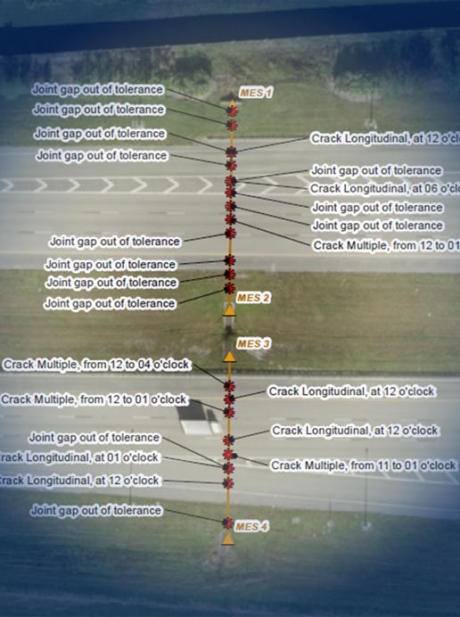
Shenandoah’s GIS mapping services physically locate and digitally document your entire stormwater and sanitary system. We map catch basins, manholes, pipe runs, connections, materials, and flow paths, then deliver that data in formats compatible with municipal GIS platforms or as standalone visual records for property managers.
Unlock Strategic Infrastructure Management
Shenandoah’s turnkey model integrates CCTV inspection and repair planning, so you can move seamlessly from locating infrastructure to assessing condition to executing solutions. One team, one workflow, complete system intelligence.
It's Not Just Data. It's Decision-Making Power.
Accurate system mapping transforms how you respond to emergencies, plan capital investments, and demonstrate compliance.
When flooding or system failures occur, every minute counts. GIS mapping eliminates the delay of searching for access points, identifying pipe runs, and determining system layout. Emergency crews arrive with actionable information, mobilize faster, and resolve issues before damage escalates — saving time, reducing costs, and protecting property.
Capital budgets built on incomplete information lead to cost overruns, scope changes, and wasted resources. GIS mapping provides the verified data needed to forecast repair costs, prioritize infrastructure investments, and justify expenditures with documented conditions. It also identifies where system enhancements will deliver the greatest impact, ensuring improvements are strategic, not reactionary.
Municipal and regulatory agencies require accurate infrastructure records for permitting, stormwater management plans, and environmental compliance. GIS mapping delivers the verified documentation needed to satisfy these requirements without gaps, inconsistencies, or last-minute scrambles. It also supports “what-if” modeling to demonstrate system capacity and pollution control effectiveness—requirements that are increasingly mandated by state and federal oversight.
Mapping reveals system layout, but when paired with condition data, it becomes a strategic maintenance tool. By charting pipe types, materials, locations, and current conditions, maintenance teams can prioritize work based on risk, schedule interventions before failures occur, and extend system life through targeted action instead of reactive emergency repairs.
Infrastructure evolves. Pipes are added, replaced, or abandoned. Connections change. GIS mapping creates a living record that’s updated as systems are modified—ensuring maintenance plans, inspection schedules, and emergency protocols stay aligned with current conditions rather than outdated assumptions.
Real Systems, Real Results
Learn how Shenandoah's GIS mapping services help clients gain control of infrastructure and asset management.
Tap Into Total Peace of Mind
When you know you have an all-in-one partner who has your back (and your infrastructure), you face the future with confidence.